
Spring 2024
Andy Brown, Eliza Thompson and Josie Hagan started September with an awesome excavation of an open pit site (V15/921) ahead of a residential development near Paengaroa, completed under authority no. 2025/014. The site consisted of three large open rectangular pits, measuring 9m x 5m x 1.5m deep, 12m x 5m x 1.5m deep and 7m x 3m x 0.3m deep. Multiple post-hole alignments were identified within the pits (Image 1). As the rest of the site was stripped of topsoil, numerous other features were identified which had no surface expression, including an area of multi-phased bowl-shaped depressions, interpreted as the imprint of kūmara puke (Image 2). Large in-filled pits, smaller infilled pits, fire scoops, and post-hole alignments dividing areas of the site were found as well as the potential post-hole alignment of a whare. The interim report has been submitted to Heritage New Zealand.
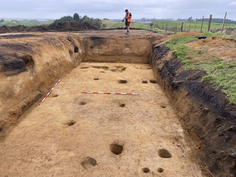
Image 1

Image 2
Later in September Josie and Eliza travelled over to Tairāwhiti to survey a proposed residential development at Lake Repongaere, which included the recorded site Y18/322 (Pit/Terrace). They next went up the coast to Uawa, to survey two areas proposed for the relocation of Puketawai Marae which was catastrophically damaged by flooding during Cyclone Gabrielle in 2023. The survey identifying an unrecorded pit (Z17/565), updated the information for recorded site Z17/181 (Image 3) and identified a historic chimney, associated with a dwelling constructed between 1914-1919. While in Tairāwhiti Eliza and Josie also did an interim post-harvest inspection of a forestry block to record a site that was found during the harvesting works. The site consists of five pits and one terrace in good condition and has been entered into ArchSite as X17/39.

Image 3
In October Eliza and Josie headed back to Tairāwhiti again, this time to monitor earthworks for the relocation of Tokomaru Bay School, which is being moved due to repeated flood events. Archaeological authority no. 2025/093 was granted for the work. Six trenches were opened in proposed new location of the Kura. The trenches revealed a deep stratigraphy of sorted river gravels with bands of silt between the stoney layers. No archaeological features were found. The team then went inland of Anaura Bay, to complete a pre-harvest inspection of Tauwhareparae Forest. Twelve recorded archaeological sites were inspected on the high inland hills, mostly consisting of pit and terrace sites, which have all been updated to ArchSite; Y16/20, Y16/21, Y16/22, Y16/23, Y16/24, Y16/25, Y16/26, Y16/27, Y16/28, Y16/29, Y16/30, Y16/89 (Pit/Terrace). One additional site initially identified by Eliza using LiDAR data was confirmed during field survey and recorded as Y16/106 (Pit/Terrace).
Later in October Eliza and Josie did another pre-harvest forestry inspection in Whirinaki Forest, which included the impressive pā V17/16 (Image 4). Other fieldwork for the team that month included a trip to Monmouth Redoubt Historic Reserve (U14/174) to monitor soil testing ahead of the start of stabilisation work at the site, intermittent monitoring of road works on Thornton Road west of Whakatāne, which have uncovered a series of small shallow midden, and field survey of a proposed new regional park north-west of Tauranga at the foot of the Kaimai ranges.

Image 4